
Sports
Ratepayers on the hook for $1.7 billion unpaid bill for Kincade, Dixie fires, regulatory judge decides
By Katherine Langford
Advertisement · Why this ad?
Marcus manages the day-to-day editorial workflow across all brands, coordinating coverage assignments and ensuring editorial standards are met. He previously served as city editor at the Pioneer Press and holds a degree in Political Science from Carleton College.
More from Marcus →
The familiar scent of eucalyptus and the promise of dry autumn days in Woodside have been replaced with a forecast of rain and wind, as a Level 2 storm heads toward the Bay Area this Friday. The approaching weather system, upgraded from earlier predictions, is expected to bring gusty winds, potentially dangerous surf conditions along the coast, and the first accumulating snowfall of the season to the Sierra Nevada mountains. While the end of fire season is a welcome relief for communities that have been battling wildfires throughout the summer and fall, residents should prepare for hazardous conditions and potential disruptions to daily life. This storm arrives after a period of below-average rainfall, highlighting the region’s vulnerability to both drought and intense precipitation events – a pattern increasingly linked to climate change and shifting atmospheric conditions.
According to ABC7 meteorologist Drew Tuma and Gloria Rodríguez, this marks the first moderate storm of the season, bringing with it a forecast of approximately half an inch of rain for most Bay Area cities, with higher amounts anticipated in the North Bay and Santa Cruz Mountains. Rainfall totals are expected to range from 0.50 to more than 1.5 inches, accompanied by wind gusts of 30 to 50 mph, peaking between 10 a.m. and 2 p.m. Friday. Showers are expected to continue into the afternoon, with a chance of thunderstorms adding to the unsettled conditions. The National Weather Service has issued a Beach Hazards Statement, effective through Friday afternoon, and a High Surf Warning for coastal areas, anticipating waves of 20 to 30 feet slamming Bay Area beaches through Saturday. The Beach Hazards Statement has been adjusted to start now and will continue through 6 PM Friday. From 6 PM Friday through 4 AM Sunday a High Surf Warning will be in effect for Pacific Coast beaches National Weather Service. This storm follows a period of unusually dry weather, and while the rain is beneficial, the intensity of the system presents challenges, particularly for areas still recovering from recent wildfire damage.
The Level 2 designation indicates a moderate storm with the potential for significant impacts. These storms, while not as severe as Level 3 or 4 events (which would trigger widespread evacuations and emergency declarations), still require heightened awareness and preparedness. The previous system, considered a Level 0 or 1, brought minimal impact. This upgrade to Level 2 signifies a shift in atmospheric conditions and the need for residents to take precautions. Historically, the Bay Area’s storm level system has been used to communicate the potential impact of weather events to the public and guide emergency response efforts. The system was implemented following a review of emergency preparedness procedures after the devastating Oroville Dam crisis in 2017, aiming for clearer communication and more proactive response. The implementation of this storm level system was a direct response to the devastating floods of 2019, which exposed vulnerabilities in the region's emergency preparedness infrastructure.
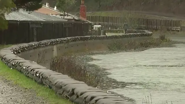
While the rain itself is welcome after a prolonged dry spell, the associated impacts are what residents need to be prepared for. The anticipated rainfall could exacerbate existing erosion issues in the North Bay and Santa Cruz Mountains, potentially leading to mudslides and road closures. These areas, particularly those scarred by previous wildfires like the 2020 SCU Complex Fire and the 2021 Caldor Fire, are especially susceptible to landslides due to the loss of vegetation and soil stabilization. The strong winds pose a risk to trees and power lines, increasing the likelihood of power outages, which can be particularly disruptive during colder temperatures. Schools may consider closures or modified schedules, and transportation delays are likely. Local businesses, particularly those reliant on outdoor activities or tourism, may experience disruptions. The storm also presents an opportunity to assess and reinforce infrastructure – a responsibility shared by city and county engineers. The potential for disruptions to public transportation, particularly BART and Caltrain, is a significant concern for commuters across the region, especially as ridership begins to rebound after pandemic-related declines.
Coastal erosion has long been a challenge for Bay Area communities. Rising sea levels, exacerbated by climate change, are accelerating this process, threatening homes, businesses, and infrastructure. The storm’s anticipated high surf will only worsen the situation, potentially causing further damage to coastal bluffs and beaches. The City of Pacifica, for example, has been grappling with severe erosion issues for decades, requiring costly stabilization efforts and relocation of homes in vulnerable areas like the Linda Mar Beach neighborhood. The storm serves as a stark reminder of the ongoing threat posed by coastal hazards and the need for proactive planning and adaptation measures. The state is currently evaluating potential strategies for managed retreat from the most vulnerable coastal areas, a complex issue with significant social and economic implications.
Pacifica surfer Craig Garza emphasized the unpredictable nature of the ocean, stating, “The water's getting aggressive. It's growing. The swell is increasing.” He warned against complacency, noting that conditions can change rapidly and urging caution, especially for those with children. Curtis Wedge echoed this sentiment, advising, “Don't let your kids out anywhere near the water. These tides will suck them kids right out. It’s dangerous.” Experienced surfers are reminding everyone to heed official warnings and avoid the water's edge Pacifica City Government. The surfing community in Pacifica, a town intrinsically tied to the ocean, relies heavily on understanding wave patterns and respecting the power of the sea.
Surfing in the Bay Area isn’t just a recreational activity; it’s a deeply ingrained part of the coastal culture. While not as renowned as surfing destinations in Southern California, the Bay Area boasts a rich history of surfing, with early pioneers drawn to the challenging breaks of Pacifica, Santa Cruz, and Half Moon Bay. The earliest documented surfing in the Bay Area dates back to the 1930s, with the sport gaining popularity throughout the mid-20th century. The evolution of surf culture has been intertwined with the region’s broader social and economic changes, reflecting trends in fashion, music, and environmental awareness. However, the inherent risks associated with Pacific Ocean swells remain ever-present, demanding respect and caution. The rise in popularity of surfing has also brought increased pressure on coastal resources and raised concerns about overcrowding and environmental impact, prompting discussions about sustainable surfing practices.
The dangers extend beyond the shoreline, as sneaker waves – powerful, unexpected surges – pose a significant threat. Officials caution that these waves can arrive without warning and sweep people into the ocean, even when conditions appear calm. The National Weather Service urges residents to “never turn your back on the ocean” and to be aware of the potential for coastal flooding, with up to 1.5 feet of tidal inundation possible in low-lying areas during high tide. A coastal flood advisory remains in effect through Friday afternoon San Francisco City Government. Coastal communities like Half Moon Bay and Bolinas are particularly vulnerable to sneaker waves, and residents are advised to familiarize themselves with safety protocols and evacuation routes.
Sneaker waves are a phenomenon that occurs when a series of smaller waves build upon each other, creating a larger, more powerful surge. These waves are often preceded by a lull in the surf, which can create a false sense of security. The unpredictable nature of sneaker waves makes them particularly dangerous, as they can catch people off guard and sweep them into the ocean. The National Weather Service provides valuable information and resources on sneaker wave safety, including tips on how to identify potential hazards and what to do if caught in a surge. Local emergency management agencies also conduct outreach programs to educate residents about the risks of coastal hazards. The scientific understanding of sneaker waves has improved in recent years, but predicting their occurrence remains a challenge, highlighting the importance of vigilance and caution.
The high surf warning isn't just a caution for surfers; it’s a serious safety concern for anyone near the coast. Even seemingly harmless activities like walking along the beach or taking photos can become dangerous when large waves are present. Local authorities recommend staying well away from the water's edge, securing loose objects that could be swept away by strong winds, and being aware of potential coastal flooding impacts on roads and infrastructure. The upcoming weekend presents a heightened risk, and residents are encouraged to monitor weather updates closely. Local shelters and community centers are also preparing for potential evacuations if coastal flooding becomes a significant threat.
Beyond the Bay Area, the storm system is bringing much-needed snow to the Sierra Nevada. Forecasters predict 6 to 12 inches of snow at lake level, with more than 18 inches possible at higher elevations. This early snowfall is a welcome sign for the ski season and provides a crucial boost to the region’s water supply, which has been struggling in recent years. The Sierra Nevada snowpack is vital for replenishing reservoirs and ensuring a reliable water source for communities throughout California California Department of Water Resources. The snowpack’s contribution to the state’s water supply is estimated to be around 30-40% annually, underscoring its critical importance. The economic impact of a strong ski season on mountain communities like Truckee and Tahoe is also significant, supporting numerous jobs and businesses. The state's snow surveyors will be closely monitoring the snowpack throughout the winter to assess its potential for water storage.
Several key questions remain unanswered. How will this storm impact already stressed infrastructure, particularly in areas scarred by recent wildfires? What long-term strategies are being developed to address coastal erosion and rising sea levels, and how can these be implemented equitably across all communities? And how can we improve public education about the dangers of sneaker waves and other coastal hazards, especially for visitors unfamiliar with the region’s unique risks? Residents should actively participate in local government discussions regarding these critical issues and advocate for proactive solutions. Furthermore, it’s crucial to stay informed about emergency preparedness plans and consider individual actions to protect homes and businesses from potential damage. The coming weeks will be critical in assessing the full impact of this storm and preparing for the inevitable weather events that lie ahead.
Woodside, California
Sports
Thursday, November 12, 2026
8 min
By Katherine Langford

By Marcus Chen
By Katherine Langford
By Marcus Chen